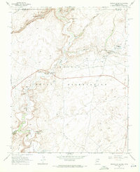
1968 Map of Mexican Water
USGS Topo · Published 1971About this map
Mexican Water serves as a focal point within the Navajo Indian Reservation on this 1968 survey, where the Old Indian Treaty Boundary meets the Utah-Arizona border. The landscape is defined by the winding course of Chinle Creek and the deep incisions of Hosteen Tso Canyon and Short Grass Canyon. Evidence of ancient habitation is scattered throughout the canyons, notably the Floating House Ruins, multiple Cliff Dwelling sites, and Petroglyphs near the Garnet Ridge.
Find a feature on this map
38 named features on this map. Tap any name to fly to it.
Don’t see what you’re looking for? This feature index may not catch every label — zoom into the map to look around manually.
Map Details
Editions of this 1968 Mexican Water Map
2 editions found
Other maps of this area

1886 · Abajo
USGS Topo · 1:250,000

1892 · Abajo
USGS Topo · 1:250,000

1892 · Canyon De Chelly
USGS Topo · 1:250,000

1893 · Abajo
USGS Topo · 1:250,000

1952 · Bluff 3 SE
USGS Topo · 1:24,000

1952 · Dinnehotso
USGS Topo · 1:62,500

1952 · Setsiltso Springs 2 SE
USGS Topo · 1:24,000

1952 · Setsiltso Springs 2 NE
USGS Topo · 1:24,000

1954 · Shiprock
USGS Topo · 1:250,000

1956 · Cortez
USGS Topo · 1:250,000
Featured Places
- Shiprock Agency
- Tes Nez Iah, Shiprock Agency
- Mexican Water, Shiprock Agency
- Apache County, AZ
- San Juan County, UT