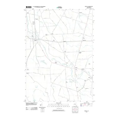
2010 Map of Mexico
USGS Topo · Published 2010About this map
Mexico serves as the focal point of this agricultural and riparian landscape in central New York, where the Little Salmon River and its various branches wind through a patchwork of family farms and historic orchards. The mapping reveals a community deeply rooted in its local land use, from the Appledale Orchards in the northwest to Great Meadows Farm in the southeast. Genealogists will find a high density of burial grounds, including the Mexico Village Cemetery, the Quaker Cemetery, and the Saint Annes Cemetery near Grays Millpond. Smaller crossroads settlements like Prattham, Colosse, and Deweys Corners punctuate the grid of rural roads, while specialized features like the Mexico Airdrome Airport and Blicon Nursery indicate the diverse economic activity of the region. The drainage patterns of Black Creek and Snake Creek define the low-lying areas, particularly near the Lot Ten Swamp in the southwest.
Find a feature on this map
91 named features on this map. Tap any name to fly to it.
Don’t see what you’re looking for? This feature index may not catch every label — zoom into the map to look around manually.
Map Details
Editions of this 2010 Mexico Map
This is the sole edition of this map. No revisions or reprints were ever made.
Other maps of this area

1895 · Pulaski
USGS Topo · 1:62,500

1900 · Fulton
USGS Topo · 1:62,500

1905 · Mexico
USGS Topo · 1:62,500

1943 · Pulaski
USGS Topo · 1:31,680

1943 · New Haven
USGS Topo · 1:31,680

1943 · Richland
USGS Topo · 1:31,680
1943 · Mallory
USGS Topo · 1:31,680

1943 · Texas
USGS Topo · 1:31,680

1943 · Mexico
USGS Topo · 1:31,680

1943 · Pennellville
USGS Topo · 1:31,680