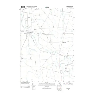
2013 Map of Mexico
USGS Topo · Published 2013About this map
Little Salmon River meanders through this portion of Oswego County, anchoring a landscape defined by small crossroads settlements and agricultural legacy. The village of Mexico serves as a central hub, surrounded by outlying hamlets such as Colosse, Prattham, and Maple View. This area is particularly dense with genealogical sites, including the Mexico Village Cem, Quaker Cem, and Saint Annes Cem. The transition from historic farming to modern land use is visible through the presence of Sage Creek Orchards and the Mexico Airdrome. In the southern reaches, Parish sits near the S Br Little Salmon River, while the presence of Grays Millpond suggests the early industrial water power that once supported local milling operations.
Find a feature on this map
119 named features on this map. Tap any name to fly to it.
Don’t see what you’re looking for? This feature index may not catch every label — zoom into the map to look around manually.
Map Details
Editions of this 2013 Mexico Map
This is the sole edition of this map. No revisions or reprints were ever made.
Other maps of this area

1895 · Pulaski
USGS Topo · 1:62,500

1900 · Fulton
USGS Topo · 1:62,500

1905 · Mexico
USGS Topo · 1:62,500

1943 · Pulaski
USGS Topo · 1:31,680

1943 · New Haven
USGS Topo · 1:31,680

1943 · Richland
USGS Topo · 1:31,680
1943 · Mallory
USGS Topo · 1:31,680

1943 · Texas
USGS Topo · 1:31,680

1943 · Mexico
USGS Topo · 1:31,680

1943 · Pennellville
USGS Topo · 1:31,680