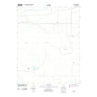
2010 Map of Miami
USGS Topo · Published 2010About this map
The high plains and mesas of Colfax County meet in this survey of Miami, a settlement defined by its agricultural layout and proximity to the Sangre de Cristo foothills. The landscape is carved by a complex network of seasonal drainages, including Rayado Creek, Salado Creek, and Moras Creek, which flow around prominent elevations like Rayado Mesa and Gonzalitos Mesa. This early 21st-century map documents the enduring rural character of the area, where isolated outposts like Valdez Place and Fernandez Ranch stand as markers of local land use. A notable passage through the terrain is Horse Thief Gap, a name that suggests the colorful frontier history of this region. The map also records the location of the Miami Cemetery, a vital site for genealogical research in this sparsely populated part of northern New Mexico.
Find a feature on this map
16 named features on this map. Tap any name to fly to it.
Don’t see what you’re looking for? This feature index may not catch every label — zoom into the map to look around manually.
Map Details
Editions of this 2010 Miami Map
This is the sole edition of this map. No revisions or reprints were ever made.
Other maps of this area

1954 · Raton
USGS Topo · 1:250,000

1956 · Miami
USGS Topo · 1:62,500

1958 · Raton
USGS Topo · 1:250,000

1964 · Colmor
USGS Topo · 1:24,000

1964 · Pinon Hills
USGS Topo · 1:24,000

1965 · Springer Lake
USGS Topo · 1:24,000

1966 · Mora Ranch
USGS Topo · 1:24,000
1966 · Charette Lake
USGS Topo · 1:24,000

1981 · Springer
USGS Topo · 1:100,000
1987 · Coyote Mesa
USGS Topo · 1:24,000