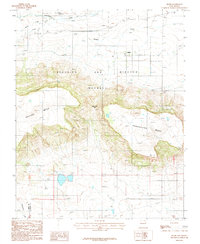
1987 Map of Miami
USGS Topo · Published 1987About this map
The Beaubien and Miranda (Maxwell) land grant dominates this high-altitude landscape where the Sangre de Cristo foothills meet the plains. Small settlements like Miami and Salado are situated near a network of drainages including Rayado Creek and Chicoso Creek. The terrain is defined by massive landforms such as Rayado Mesa and Gonzalitos Mesa, separated by the distinct Horse Thief Gap. An Abandoned Canal and various Corral sites point to the region's agricultural and ranching history, while the southern border tracks the Mora Co Colfax Co line. This 1980s survey provides a detailed look at the water management and cattle-ranching infrastructure that sustained these isolated northern New Mexico communities.
Find a feature on this map
17 named features on this map. Tap any name to fly to it.
Don’t see what you’re looking for? This feature index may not catch every label — zoom into the map to look around manually.
Map Details
Editions of this 1987 Miami Map
This is the sole edition of this map. No revisions or reprints were ever made.
Other maps of this area

1954 · Raton
USGS Topo · 1:250,000

1956 · Miami
USGS Topo · 1:62,500

1958 · Raton
USGS Topo · 1:250,000

1964 · Colmor
USGS Topo · 1:24,000

1964 · Pinon Hills
USGS Topo · 1:24,000

1965 · Springer Lake
USGS Topo · 1:24,000

1966 · Mora Ranch
USGS Topo · 1:24,000
1966 · Charette Lake
USGS Topo · 1:24,000

1981 · Springer
USGS Topo · 1:100,000
1987 · Coyote Mesa
USGS Topo · 1:24,000