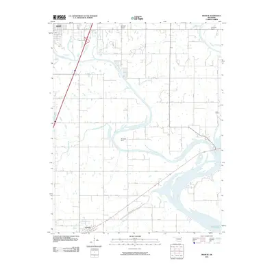
2010 Map of Miami SE
USGS Topo · Published 2010About this map
The Neosho River meanders across this landscape, defining the topography south of Miami as it flows toward the expansive waters of Grand Lake O' The Cherokees. This 2010 survey illustrates the meeting of several significant water bodies, including the Spring River and numerous tributaries like Hudson Creek and Little Elm Creek. The terrain is marked by distinctive river features such as Mudeater Bend and Moccasin Bend, reflecting the natural hydrology of the area before reaching the reservoir.
Find a feature on this map
45 named features on this map. Tap any name to fly to it.
Don’t see what you’re looking for? This feature index may not catch every label — zoom into the map to look around manually.
Map Details
Editions of this 2010 Miami SE Map
This is the sole edition of this map. No revisions or reprints were ever made.
Other maps of this area

1907 · Wyandotte
USGS Topo · 1:125,000

1909 · Wyandotte
USGS Topo · 1:125,000

1954 · Tulsa
USGS Topo · 1:250,000

1958 · Tulsa
USGS Topo · 1:250,000
1960 · Peoria
USGS Topo · 1:24,000

1961 · Miami SE
USGS Topo · 1:24,000
1961 · Miami NW
USGS Topo · 1:24,000

1961 · Wyandotte
USGS Topo · 1:24,000

1961 · Miami SW
USGS Topo · 1:24,000
1961 · Picher
USGS Topo · 1:24,000