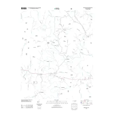
2013 Map of Micaville
USGS Topo · Published 2013About this map
The confluence of the N Toe River and S Toe River anchor this 2013 survey of the western North Carolina mountains. The landscape is defined by its deep connectivity between valley settlements and high-altitude landmarks, such as Thunderstruck Knob and Chestnut Mountain. Small communities like Micaville, Bandana, and Lunday follow the river bends and mountain gaps, while industrial traces persist through names like Griffith Mine Rd and the spar-processing history near Bowditch. Transportation routes such as NC-1311 and NC-1315 navigate the winding terrain between ridges like Narrow Ridge and Bald Knob Ridge. This map captures a moment of modern rural continuity in the Blue Ridge, where local identity is tied to the dramatic topography of Hootowl Hollow and the peaks surrounding Double Island.
Find a feature on this map
159 named features on this map. Tap any name to fly to it.
Don’t see what you’re looking for? This feature index may not catch every label — zoom into the map to look around manually.
Map Details
Editions of this 2013 Micaville Map
This is the sole edition of this map. No revisions or reprints were ever made.
Other maps of this area

1891 · Roan Mountain
USGS Topo · 1:125,000

1894 · Roan Mountain
USGS Topo · 1:125,000

1900 · Mount Mitchell
USGS Topo · 1:125,000

1902 · Mount Mitchell
USGS Topo · 1:125,000

1904 · Roan Mountain
USGS Topo · 1:125,000

1934 · Micaville
USGS Topo · 1:24,000

1934 · Spruce Pine
USGS Topo · 1:24,000

1934 · Parts Of Celo And Black Brothers
USGS Topo · 1:24,000

1934 · Bakersville
USGS Topo · 1:24,000
1934 · Carvers Gap
USGS Topo · 1:24,000