
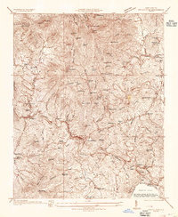
1934 Map of Parts Of Celo And Black Brothers
USGS Topo · Published 1934About this map
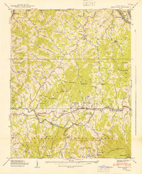
Celo and the surrounding high-elevation settlements of Yancey County are captured in this mid-1930s survey, showing a landscape defined by the drainage of the South Toe River. The map illustrates a rural social infrastructure of small crossroads and family-named landmarks like Edges Store and Ballews Store, alongside community centers such as Harvard Sch and Halls Chapel. As the era of large-scale timber extraction transitioned into federal conservation, the boundaries of Pisgah National Forest and Mt Mitchell State Park overlap these rugged slopes.
Find a feature on this map
80 named features on this map. Tap any name to fly to it.
Don’t see what you’re looking for? This feature index may not catch every label — zoom into the map to look around manually.
Map Details
Editions of this 1934 Parts Of Celo And Black Brothers Map
This is the sole edition of this map. No revisions or reprints were ever made.
Other maps of this area

1900 · Mount Mitchell
USGS Topo · 1:125,000

1902 · Mount Mitchell
USGS Topo · 1:125,000

1934 · Micaville
USGS Topo · 1:24,000
1934 · Spruce Pine
USGS Topo · 1:24,000

1934 · Parts Of Old Fort and Montreat
USGS Topo · 1:24,000
1935 · Montreat
USGS Topo · 1:24,000

1935 · Black Brothers
USGS Topo · 1:24,000
1935 · Burnsville
USGS Topo · 1:24,000
1939 · Burnsville
USGS Topo · 1:24,000
1940 · Burnsville
USGS Topo · 1:24,000