1935 Map of Burnsville
USGS Topo · Published 1935About this map
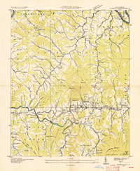
The Cane River valley and its surrounding mountain ridges dominate this mid-1930s landscape, centered on the growing town of Burnsville. In an era where the Tennessee Valley Authority was actively reshaping the region’s topography and utility networks, this map shows a community defined by its proximity to steep terrain and water. The arrival of transportation and infrastructure is evident in the Clinchfield RR and the State Prison Camp, while numerous small community hubs like Day Book and Windom are anchored by local institutions such as West Burnsville Ch and the Mine Fork Sch.
Find a feature on this map
84 named features on this map. Tap any name to fly to it.
Don’t see what you’re looking for? This feature index may not catch every label — zoom into the map to look around manually.
Map Details
Editions of this 1935 Burnsville Map
This is the sole edition of this map. No revisions or reprints were ever made.
Other maps of this area

1891 · Roan Mountain
USGS Topo · 1:125,000

1894 · Roan Mountain
USGS Topo · 1:125,000

1900 · Mount Mitchell
USGS Topo · 1:125,000

1902 · Mount Mitchell
USGS Topo · 1:125,000

1904 · Roan Mountain
USGS Topo · 1:125,000

1934 · Micaville
USGS Topo · 1:24,000

1934 · Parts Of Celo And Black Brothers
USGS Topo · 1:24,000

1934 · Bakersville
USGS Topo · 1:24,000

1935 · Black Brothers
USGS Topo · 1:24,000

1935 · Chestoa
USGS Topo · 1:24,000