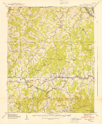
1940 Map of Burnsville
USGS Topo · Published 1940About this map
Burnsville serves as the central hub for this corner of Yancey County, situated in a valley between the massive Ramseytown Mountain and the southern reaches of the Pisgah National Forest. This 1940 edition documents a landscape defined by small mountain settlements and rural institutions, including the State Prison Camp near Riverside and the Mt Mitchell Boys Camp along the Cane River. The region's social structure is traced through numerous neighborhood schools and churches, such as Clearmont School and Miller Chapel.
Find a feature on this map
183 named features on this map. Tap any name to fly to it.
Don’t see what you’re looking for? This feature index may not catch every label — zoom into the map to look around manually.
Map Details
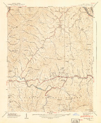
Editions of this 1940 Burnsville Map
2 editions found
Other maps of this area

1891 · Roan Mountain
USGS Topo · 1:125,000

1894 · Roan Mountain
USGS Topo · 1:125,000

1900 · Mount Mitchell
USGS Topo · 1:125,000

1902 · Mount Mitchell
USGS Topo · 1:125,000

1904 · Roan Mountain
USGS Topo · 1:125,000

1934 · Micaville
USGS Topo · 1:24,000

1934 · Parts Of Celo And Black Brothers
USGS Topo · 1:24,000

1934 · Bakersville
USGS Topo · 1:24,000

1935 · Black Brothers
USGS Topo · 1:24,000

1935 · Chestoa
USGS Topo · 1:24,000