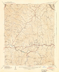
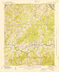
1940 Map of Burnsville
USGS Topo · Published 1940About this map
Burnsville serves as the central hub of this Yancey County landscape, surveyed just before the 1940s. The town's layout and surrounding valley roads reveal a community deeply connected by the Cane River, which winds through the mountain passes alongside smaller settlements like Riverside and Windom. The map captures a transition in local infrastructure, showing the State Prison Camp near the river and the Mt Mitchell Boys Camp tucked along Creek.
Find a feature on this map
150 named features on this map. Tap any name to fly to it.
Don’t see what you’re looking for? This feature index may not catch every label — zoom into the map to look around manually.
Map Details
Editions of this 1940 Burnsville Map
2 editions found
Other maps of this area

1891 · Roan Mountain
USGS Topo · 1:125,000

1894 · Roan Mountain
USGS Topo · 1:125,000

1900 · Mount Mitchell
USGS Topo · 1:125,000

1902 · Mount Mitchell
USGS Topo · 1:125,000

1904 · Roan Mountain
USGS Topo · 1:125,000

1934 · Micaville
USGS Topo · 1:24,000

1934 · Parts Of Celo And Black Brothers
USGS Topo · 1:24,000

1934 · Bakersville
USGS Topo · 1:24,000

1935 · Black Brothers
USGS Topo · 1:24,000

1935 · Chestoa
USGS Topo · 1:24,000