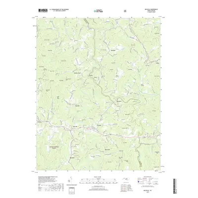
2019 Map of Micaville
USGS Topo · Published 2019About this map
The South Toe River and North Toe River carve through the mountain terrain of this Mitchell and Yancey County borderland. Centered on the settlement of Micaville, the map illustrates a landscape shaped by both the timber resources of the Pisgah National Forest and a legacy of local extraction, evidenced by landmarks such as Mine Knob and Mine Br. Small communities like Bandana, Lunday, and Newdale are connected by a network of winding roads including State Rd 1311 and State Rd 1002. The map is particularly valuable for genealogical research, documenting numerous family burial sites such as Hensley Cem, Wyatt Cem, and Rebels Creek Cem. From the heights of Sevenmile Ridge to the valley floors, the distribution of these cemeteries and small church congregations like Big Crabtree Church reflects the scattered settlement patterns of these Appalachian highlands.
Find a feature on this map
188 named features on this map. Tap any name to fly to it.
Don’t see what you’re looking for? This feature index may not catch every label — zoom into the map to look around manually.
Map Details
Editions of this 2019 Micaville Map
This is the sole edition of this map. No revisions or reprints were ever made.
Other maps of this area

1891 · Roan Mountain
USGS Topo · 1:125,000

1894 · Roan Mountain
USGS Topo · 1:125,000

1900 · Mount Mitchell
USGS Topo · 1:125,000

1902 · Mount Mitchell
USGS Topo · 1:125,000

1904 · Roan Mountain
USGS Topo · 1:125,000

1934 · Micaville
USGS Topo · 1:24,000

1934 · Spruce Pine
USGS Topo · 1:24,000

1934 · Parts Of Celo And Black Brothers
USGS Topo · 1:24,000

1934 · Bakersville
USGS Topo · 1:24,000
1934 · Carvers Gap
USGS Topo · 1:24,000