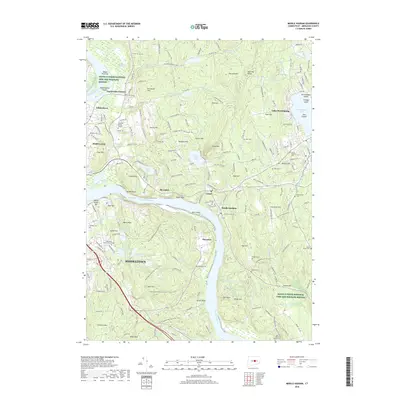
2018 Map of Middle Haddam
USGS Topo · Published 2018About this map
The Connecticut River defines the landscape of this Lower Connecticut River Valley region, carving a deep bend around Maromas and passing the riverfront settlements of Middle Haddam, Cobalt, and Gildersleeve. In the western reaches, the city of Middletown and the town of Portland serve as primary hubs, with Middlesex Community College situated near the urban edge. The terrain is marked by numerous hills and ridges, including Chestnut Hill and the Bald Hill Range, which hem in a network of water bodies like Pocotopaug Lake and Great Hill Pond.
Find a feature on this map
144 named features on this map. Tap any name to fly to it.
Don’t see what you’re looking for? This feature index may not catch every label — zoom into the map to look around manually.
Map Details
Editions of this 2018 Middle Haddam Map
This is the sole edition of this map. No revisions or reprints were ever made.
Other maps of this area

1892 · Gilead
USGS Topo · 1:62,500

1893 · Guilford
USGS Topo · 1:62,500

1893 · Middletown
USGS Topo · 1:62,500

1893 · Saybrook
USGS Topo · 1:62,500

1906 · Farmington
USGS Topo · 1:125,000

1928 · Cromwell
USGS Topo · 1:24,000

1928 · Glastonbury
USGS Topo · 1:24,000

1943 · Durham
USGS Topo · 1:25,000

1944 · Hartford South
USGS Topo · 1:31,680

1944 · Marlboro
USGS Topo · 1:31,680