
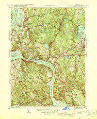
1945 Map of Middle Haddam
USGS Topo · Published 1945About this map
The Connecticut River carves a deep, winding path through this mid-century landscape, passing through the narrow passage of The Straits and beneath landmarks like St Clements Castle. Settlement patterns in the 1940s are concentrated in Portland, East Hampton, and Middle Haddam, with the New York New Haven and Hartford railroad providing a vital corridor for commerce and travel. The area is heavily marked by its granite and brownstone history, with numerous hills like Indian Hill and White Rocks overlooking the water.
Find a feature on this map
84 named features on this map. Tap any name to fly to it.
Don’t see what you’re looking for? This feature index may not catch every label — zoom into the map to look around manually.
Map Details
Editions of this 1945 Middle Haddam Map
2 editions found
Other maps of this area

1892 · Gilead
USGS Topo · 1:62,500

1893 · Guilford
USGS Topo · 1:62,500

1893 · Middletown
USGS Topo · 1:62,500

1893 · Saybrook
USGS Topo · 1:62,500

1906 · Farmington
USGS Topo · 1:125,000

1928 · Cromwell
USGS Topo · 1:24,000

1928 · Glastonbury
USGS Topo · 1:24,000

1943 · Durham
USGS Topo · 1:25,000

1944 · Hartford South
USGS Topo · 1:31,680

1944 · Marlboro
USGS Topo · 1:31,680