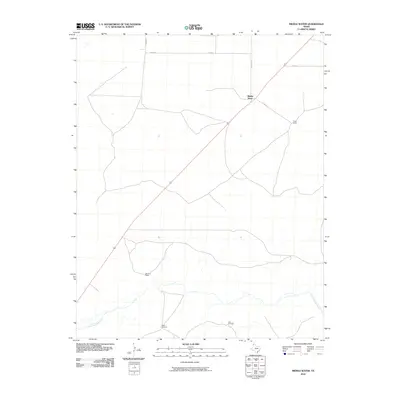
2010 Map of Middle Water
USGS Topo · Published 2010About this map
Middle Water serves as the focal point of this High Plains landscape in Hartley County, situated where a major transportation corridor cuts diagonally across the open range. The topography is defined by the drainage of Punta de Agua Creek, which winds through the southern portion of the quadrangle. This 2010 survey illustrates a region where life is oriented around ranching operations and water management, evidenced by the named livestock holdings like Taylor Ranch and Dammier Ranch. The importance of water infrastructure in this arid environment is highlighted by functional landmarks such as the Steel Windmill and Red Windmill, which stand as vital points of interest for local geography. A network of rural roads including Byrd Rd and Brown Rd provides access to these isolated outposts, tracing the grid-like distribution of land in the Texas Panhandle.
Find a feature on this map
10 named features on this map. Tap any name to fly to it.
Don’t see what you’re looking for? This feature index may not catch every label — zoom into the map to look around manually.
Map Details
Editions of this 2010 Middle Water Map
This is the sole edition of this map. No revisions or reprints were ever made.
Other maps of this area

1954 · Tucumcari
USGS Topo · 1:250,000

1958 · Tucumcari
USGS Topo · 1:250,000

1971 · Middle Water
USGS Topo · 1:24,000

1971 · Syndicate Hills
USGS Topo · 1:24,000

1971 · Beck Ranch
USGS Topo · 1:24,000

1971 · Whiteaker Ranch
USGS Topo · 1:24,000

1971 · Spring Creek Ranch
USGS Topo · 1:24,000
1971 · Romero
USGS Topo · 1:24,000

1971 · Pedarosa Camp
USGS Topo · 1:24,000

1973 · King SW
USGS Topo · 1:24,000