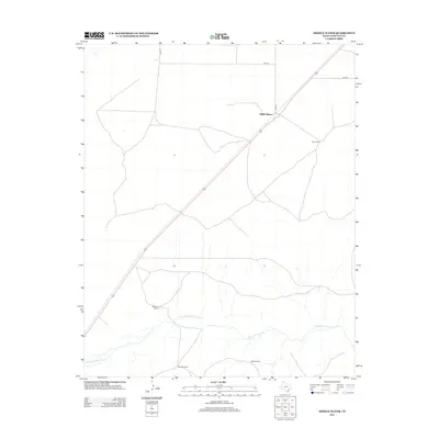
2012 Map of Middle Water
USGS Topo · Published 2012About this map
Middle Water serves as a focal point in this high plains landscape of Hartley County, where the infrastructure of Texas ranching is clearly delineated. The map shows a transition from structured transportation corridors like Co Rd-16 and Co Rd N to the essential water resources of the Panhandle. Meandering through the southern half of the quadrangle, Punta de Agua Cr provides a lifeline for the area's established ranching operations. Land use is defined by sprawling holdings such as the Taylor Ranch and Dammier Ranch, supported by functional landmarks like Steel Windmill and Red Windmill. The alignment of roads and the presence of these named windmills illustrate the practicalities of land management in this arid stretch of West Texas.
Find a feature on this map
9 named features on this map. Tap any name to fly to it.
Don’t see what you’re looking for? This feature index may not catch every label — zoom into the map to look around manually.
Map Details
Editions of this 2012 Middle Water Map
This is the sole edition of this map. No revisions or reprints were ever made.
Other maps of this area

1954 · Tucumcari
USGS Topo · 1:250,000

1958 · Tucumcari
USGS Topo · 1:250,000

1971 · Middle Water
USGS Topo · 1:24,000

1971 · Syndicate Hills
USGS Topo · 1:24,000

1971 · Beck Ranch
USGS Topo · 1:24,000

1971 · Whiteaker Ranch
USGS Topo · 1:24,000

1971 · Spring Creek Ranch
USGS Topo · 1:24,000
1971 · Romero
USGS Topo · 1:24,000

1971 · Pedarosa Camp
USGS Topo · 1:24,000

1973 · King SW
USGS Topo · 1:24,000