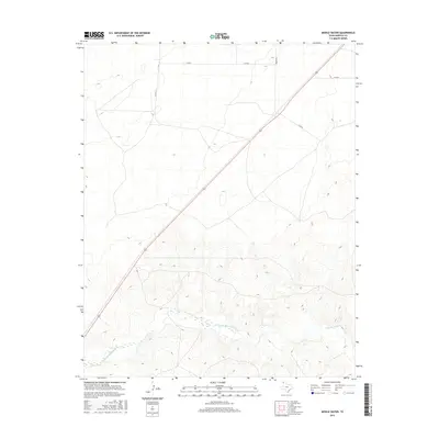
2016 Map of Middle Water
USGS Topo · Published 2016About this map
Punta de Agua Cr meanders across the southern reaches of this Hartley County landscape, defining the local hydrology in an otherwise semi-arid ranching region. The terrain is marked by established family and commercial ranching outposts, including Beck Ranch, Whiteaker Ranch, and the Spring Creek Ranch. These sites, along with the Pedarosa Camp, indicate a persistent pattern of land use centered on cattle and water access in the Texas Panhandle. Transportation is dominated by the diagonal path of Route 54, which cuts through the heart of the area, connecting remote settlements like Romero and King. The presence of the Syndicate Hills provides a rare point of topographical variation in this high plains expanse, serving as a landmark for the network of rural routes such as Co RD 13 and Brown Rd.
Find a feature on this map
14 named features on this map. Tap any name to fly to it.
Don’t see what you’re looking for? This feature index may not catch every label — zoom into the map to look around manually.
Map Details
Editions of this 2016 Middle Water Map
This is the sole edition of this map. No revisions or reprints were ever made.
Other maps of this area

1954 · Tucumcari
USGS Topo · 1:250,000

1958 · Tucumcari
USGS Topo · 1:250,000

1971 · Middle Water
USGS Topo · 1:24,000

1971 · Syndicate Hills
USGS Topo · 1:24,000

1971 · Beck Ranch
USGS Topo · 1:24,000

1971 · Whiteaker Ranch
USGS Topo · 1:24,000

1971 · Spring Creek Ranch
USGS Topo · 1:24,000
1971 · Romero
USGS Topo · 1:24,000

1971 · Pedarosa Camp
USGS Topo · 1:24,000

1973 · King SW
USGS Topo · 1:24,000