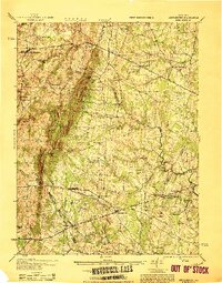
1933 Map of Middleburg
USGS Topo · Published 1933About this map
Bull Run Mountains dominate this portion of Northern Virginia, forming a prominent geological spine that separates the rolling farmland of Middleburg from the historic plains of the east. This 1933 survey details a landscape deeply connected to the American Civil War, featuring the grounds of the Second Battle of Bull Run with the Henry House, Stonehouse, and a Confederate Monument near Groveton. The road network is anchored by the Lee Highway and Jackson Memorial Highway, tracing routes between long-established settlements such as Haymarket and Aldie. Smaller rural communities and post offices like Lenah PO and Waterfall PO reflect the era's local economy, while landmarks like Beverly Mill and Waverly Mill highlight the importance of water power along the local runs. Topographical details reveal significant gaps in the ridge, including Thoroughfare Gap and Hopewell Gap, which served as critical passage points for the Southern Railway and early regional travelers.
Find a feature on this map
82 named features on this map. Tap any name to fly to it.
Don’t see what you’re looking for? This feature index may not catch every label — zoom into the map to look around manually.
Map Details
Editions of this 1933 Middleburg Map
This is the sole edition of this map. No revisions or reprints were ever made.
Other maps of this area

1884 · Harpers Ferry
USGS Topo · 1:125,000

1890 · Mt. Vernon
USGS Topo · 1:125,000

1891 · Harpers Ferry
USGS Topo · 1:125,000

1891 · Mt. Vernon
USGS Topo · 1:125,000

1893 · Frederick
USGS Topo · 1:125,000

1893 · Harpers Ferry
USGS Topo · 1:125,000

1894 · Warrenton
USGS Topo · 1:125,000

1894 · Frederick
USGS Topo · 1:125,000
1894 · Warrenton
USGS Topo · 1:62,500

1894 · Mt. Vernon
USGS Topo · 1:125,000