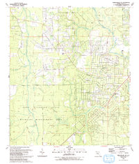
1993 Map of Middleburg SW
USGS Topo · Published 1993About this map
Camp Blanding State Wildlife Management Area anchors the southern half of this landscape, its boundary defined by the Camp Blanding Military Reservation Bdy and a network of sandy tracks like Arrowhead Road. To the north, the terrain transitions into a more developed residential and agricultural grid, where small settlements like Hattie and Nolan are connected by local routes such as Nolan Road and Louie Carter Road. This 1993 revision reflects a rural community still organized around its historical foundations.
Find a feature on this map
42 named features on this map. Tap any name to fly to it.
Don’t see what you’re looking for? This feature index may not catch every label — zoom into the map to look around manually.
Map Details
Editions of this 1993 Middleburg SW Map
This is the sole edition of this map. No revisions or reprints were ever made.
Other maps of this area

1918 · Middleburg
USGS Topo · 1:62,500

1918 · Lawtey
USGS Topo · 1:62,500

1941 · Starke
USGS Topo · 1:62,500

1941 · Middleburg
USGS Topo · 1:62,500

1942 · Ates Creek
USGS Topo · 1:62,500

1948 · Starke
USGS Topo · 1:50,000

1948 · Jacksonville
USGS Topo · 1:250,000

1949 · Middleburg SW
USGS Topo · 1:24,000

1949 · Fiftone
USGS Topo · 1:24,000

1949 · Starke
USGS Topo · 1:24,000