
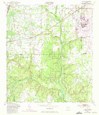
1949 Map of Fiftone
USGS Topo · Published 1953About this map
Cecil Naval Auxiliary Air Station dominates the eastern landscape of this late 1940s survey, showing the military infrastructure footprint along the Duval and Clay County line. The terrain is defined by a dense network of tributaries including Yellow Water Creek and the North Fork Black Creek, which carve through the low-lying Florida pine lands. Small settlements like Fiftone and Moore sit along the Seaboard Air Line railroad, reflecting the importance of rail transport to these rural communities. Local life is centered around rural landmarks such as Long Branch Ch and Mt Zion Ch, which serve as anchors for the scattered homesteads. The presence of numerous named branches, such as Sol Taylor Creek and Caldwell Branch, highlights the intricate drainage patterns of the region before significant modern development.
Find a feature on this map
20 named features on this map. Tap any name to fly to it.
Don’t see what you’re looking for? This feature index may not catch every label — zoom into the map to look around manually.
Map Details
Editions of this 1949 Fiftone Map
2 editions found
Other maps of this area

1917 · Cambon
USGS Topo · 1:62,500

1917 · Macclenny
USGS Topo · 1:62,500

1918 · Middleburg
USGS Topo · 1:62,500

1918 · Lawtey
USGS Topo · 1:62,500

1918 · Cambon
USGS Topo · 1:62,500

1918 · Macclenny
USGS Topo · 1:62,500

1941 · Middleburg
USGS Topo · 1:62,500

1948 · Jacksonville
USGS Topo · 1:250,000

1949 · Middleburg SW
USGS Topo · 1:24,000

1949 · Middleburg
USGS Topo · 1:24,000