1949 Map of Fiftone
USGS Topo · Published 1972About this map
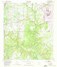
Naval Air Station (Cecil Field) dominates the northeastern quadrant of this landscape, marking a significant military presence on the border of Duval Co and Clay Co. The map captures the area during a period of transition, with the military installation’s rigid infrastructure contrasting sharply against the meandering drainage basins of Yellow Water Creek and its many tributaries. Further west, the Seaboard Coast Line railroad cuts across the terrain, serving the small community of Fiftone.
Find a feature on this map
18 named features on this map. Tap any name to fly to it.
Don’t see what you’re looking for? This feature index may not catch every label — zoom into the map to look around manually.
Map Details
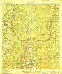
Editions of this 1949 Fiftone Map
2 editions found
Other maps of this area

1917 · Cambon
USGS Topo · 1:62,500

1917 · Macclenny
USGS Topo · 1:62,500

1918 · Middleburg
USGS Topo · 1:62,500

1918 · Lawtey
USGS Topo · 1:62,500

1918 · Cambon
USGS Topo · 1:62,500
1918 · Macclenny
USGS Topo · 1:62,500

1941 · Middleburg
USGS Topo · 1:62,500

1948 · Jacksonville
USGS Topo · 1:250,000
1949 · Middleburg SW
USGS Topo · 1:24,000

1949 · Fiftone
USGS Topo · 1:24,000