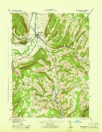
1946 Map of Middleburgh
USGS Topo · Published 1946About this map
Middleburg sits at the heart of this valley landscape, where the waters of Schoharie Creek and Little Schoharie Creek converge. The terrain is marked by distinctive elevations such as Vromans Nose and Hony Hill, which overlook a network of hollows and small settlements. In the southern portion of the quadrangle, Franklinton and The Vlaie stand near the headwaters of Catskill Creek, illustrating the complex drainage patterns of this upland region.
Find a feature on this map
32 named features on this map. Tap any name to fly to it.
Don’t see what you’re looking for? This feature index may not catch every label — zoom into the map to look around manually.
Map Details
Editions of this 1946 Middleburgh Map
This is the sole edition of this map. No revisions or reprints were ever made.
Other maps of this area

1893 · Durham
USGS Topo · 1:62,500

1894 · Durham
USGS Topo · 1:62,500

1898 · Schoharie
USGS Topo · 1:62,500

1900 · Schoharie
USGS Topo · 1:62,500

1900 · Schoharie
USGS Topo · 1:31,680

1900 · Berne
USGS Topo · 1:62,500

1901 · Gilboa
USGS Topo · 1:62,500

1903 · Gilboa
USGS Topo · 1:62,500

1903 · Berne
USGS Topo · 1:62,500

1943 · Cobleskill
USGS Topo · 1:24,000