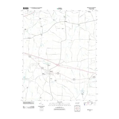
2010 Map of Middlesex
USGS Topo · Published 2010About this map
Middlesex serves as the central hub of this landscape, surrounded by a network of rural crossroads and farming communities in Nash County. The area is defined by its numerous small water systems, including Turkey Creek, Moccasin Creek, and Beaverdam Creek, which supported early industry and local agriculture. The presence of Taylors Millpond and Underwoods Mill reflects the long-standing water-powered economy of the region. Local heritage is preserved in sites like Middlesex Cemetery and Middlesex Memorial Gardens, while the transition from traditional commerce to modern utility is seen in features like the JW Stone Airport. Significant landmarks such as Chamblees Bridge, Creech Bridge, and Wilder Bridge denote historical crossing points over the winding branches and prongs that feed into the larger creek systems. The survey also highlights various local focal points such as Union Hope, Social Plains, and Rogers Crossroads, documenting the dispersed settlement pattern of the early twenty-first century.
Find a feature on this map
83 named features on this map. Tap any name to fly to it.
Don’t see what you’re looking for? This feature index may not catch every label — zoom into the map to look around manually.
Map Details
Editions of this 2010 Middlesex Map
This is the sole edition of this map. No revisions or reprints were ever made.
Other maps of this area

1902 · Kenly
USGS Topo · 1:62,500

1902 · Spring Hope
USGS Topo · 1:62,500

1903 · Kenly
USGS Topo · 1:62,500

1904 · Springhope
USGS Topo · 1:62,500

1953 · Raleigh
USGS Topo · 1:250,000

1954 · Raleigh
USGS Topo · 1:250,000

1964 · Flowers
USGS Topo · 1:24,000

1964 · Selma
USGS Topo · 1:62,500

1968 · Bunn West
USGS Topo · 1:24,000
1968 · Zebulon
USGS Topo · 1:24,000