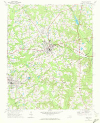
1968 Map of Zebulon
USGS Topo · Published 1972About this map
The town of Zebulon serves as a central hub in this late 1960s study, where the Norfolk Southern railroad cuts a diagonal path through the landscape. The region’s educational and civic heritage is anchored by landmarks like Wakelon High Sch and Shepard High Sch, while small outlying settlements such as Wakefield, Earpsboro, and the uniquely named Lizard Lick define the rural character.
Find a feature on this map
43 named features on this map. Tap any name to fly to it.
Don’t see what you’re looking for? This feature index may not catch every label — zoom into the map to look around manually.
Map Details
Editions of this 1968 Zebulon Map
3 editions found
Other maps of this area

1902 · Kenly
USGS Topo · 1:62,500

1902 · Spring Hope
USGS Topo · 1:62,500

1903 · Kenly
USGS Topo · 1:62,500

1904 · Springhope
USGS Topo · 1:62,500

1953 · Raleigh
USGS Topo · 1:250,000

1954 · Raleigh
USGS Topo · 1:250,000

1964 · Flowers
USGS Topo · 1:24,000

1964 · Selma
USGS Topo · 1:62,500

1964 · Clayton
USGS Topo · 1:24,000

1967 · Knightdale
USGS Topo · 1:24,000