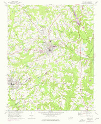
1968 Map of Zebulon
USGS Topo · Published 1975About this map
The Norfolk Southern railway corridor defines the early development of Eastern Wake County, connecting the bustling centers of Zebulon and Wendell. This 1968 landscape is characterized by its numerous small communities and crossroads, including the uniquely named Lizard Lick and the historic settlement of Wakefield. The geography is intricately tied to the waters of the Little River and Moccasin Creek, which dictate the placement of local infrastructure like Morpheus Bridge.
Find a feature on this map
40 named features on this map. Tap any name to fly to it.
Don’t see what you’re looking for? This feature index may not catch every label — zoom into the map to look around manually.
Map Details
Editions of this 1968 Zebulon Map
3 editions found
Other maps of this area

1902 · Kenly
USGS Topo · 1:62,500

1902 · Spring Hope
USGS Topo · 1:62,500

1903 · Kenly
USGS Topo · 1:62,500

1904 · Springhope
USGS Topo · 1:62,500

1953 · Raleigh
USGS Topo · 1:250,000

1954 · Raleigh
USGS Topo · 1:250,000

1964 · Flowers
USGS Topo · 1:24,000

1964 · Selma
USGS Topo · 1:62,500

1964 · Clayton
USGS Topo · 1:24,000

1967 · Knightdale
USGS Topo · 1:24,000