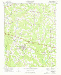
1978 Map of Middlesex
USGS Topo · Published 1978About this map
Middlesex serves as the central hub of this late-1970s landscape, situated where the Norfolk Southern railroad intersects with local agricultural life. The map captures a detailed transition between the rural crossroads of Rocky Cross and Rogers Crossroads and the established town center. Genealogists and local historians can trace numerous community landmarks, including Union Hope Chapel, St Bethel Ch, and Stony Hill Cem Ch.
Find a feature on this map
39 named features on this map. Tap any name to fly to it.
Don’t see what you’re looking for? This feature index may not catch every label — zoom into the map to look around manually.
Map Details
Editions of this 1978 Middlesex Map
This is the sole edition of this map. No revisions or reprints were ever made.
Other maps of this area

1902 · Kenly
USGS Topo · 1:62,500

1902 · Spring Hope
USGS Topo · 1:62,500

1903 · Kenly
USGS Topo · 1:62,500

1904 · Springhope
USGS Topo · 1:62,500

1953 · Raleigh
USGS Topo · 1:250,000

1954 · Raleigh
USGS Topo · 1:250,000

1964 · Flowers
USGS Topo · 1:24,000

1964 · Selma
USGS Topo · 1:62,500

1968 · Bunn West
USGS Topo · 1:24,000
1968 · Zebulon
USGS Topo · 1:24,000