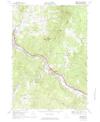
1968 Map of Middlesex
USGS Topo · Published 1983About this map
Winooski River carves a deep valley through the Worcester Mountains and Northfield Mountains, serving as the primary corridor for regional transit and settlement in central Vermont. The landscape is defined by clustered villages such as Colbyville, Mill Village, and Middlesex, which sit alongside the river's winding course. This late-1960s perspective captures the modernization of the valley as the Interstate system introduces Interchange 10 and Interchange 9, drastically altering the traditional footprints of these historic river towns. High above the valley floor, older patterns of land use remain visible at Kneeland Flat and Moretown Common, where early agricultural settlements were established on more level upland terrain. To the north, the protected acreage of Mount Mansfield State Forest brackets the high peaks of Blush Hill and Densmore Mtn, while local history is preserved in sites like Fairmount Cem and Middlesex Center Cem.
Find a feature on this map
42 named features on this map. Tap any name to fly to it.
Don’t see what you’re looking for? This feature index may not catch every label — zoom into the map to look around manually.
Map Details
Editions of this 1968 Middlesex Map
2 editions found
Other maps of this area

1919 · Lincoln Mountain
USGS Topo · 1:62,500

1919 · Montpelier
USGS Topo · 1:62,500

1920 · Lincoln Mountain
USGS Topo · 1:48,000

1921 · Richmond
USGS Topo · 1:48,000

1921 · Lincoln Mountain
USGS Topo · 1:62,500

1921 · Montpelier
USGS Topo · 1:62,500

1922 · Barre
USGS Topo · 1:48,000

1924 · Barre
USGS Topo · 1:62,500

1924 · Camels Hump
USGS Topo · 1:62,500

1944 · Montpelier
USGS Topo · 1:62,500