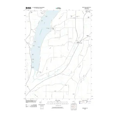
2010 Map of Middlesex
USGS Topo · Published 2010About this map
Canandaigua Lake dominates the western edge of this landscape, where steep bluffs drop toward the water at Bare Hill and South Hill. Along the southern tip of the lake, the settlement of Woodville marks the mouth of the West River, which meanders through a broad valley protected by the Hi-Tor Preserve. This conservation area anchors the wetland corridor between the high ridges, providing a glimpse into the natural topography that shaped early settlement patterns. Further east, the village of Middlesex serves as a central hub, surrounded by several family-named landmarks and burial grounds like the Middlesex Center Cemetery and Overackers Corners Cemetery. The terrain transitions into the distinct Italy Valley at the southeastern corner, where Flint Creek carves through the upland country.
Find a feature on this map
78 named features on this map. Tap any name to fly to it.
Don’t see what you’re looking for? This feature index may not catch every label — zoom into the map to look around manually.
Map Details
Editions of this 2010 Middlesex Map
This is the sole edition of this map. No revisions or reprints were ever made.
Other maps of this area

1900 · Naples
USGS Topo · 1:62,500

1900 · Canandaigua
USGS Topo · 1:62,500

1902 · Phelps
USGS Topo · 1:62,500

1903 · Naples
USGS Topo · 1:62,500

1903 · Canandaigua
USGS Topo · 1:62,500

1903 · Penn Yan
USGS Topo · 1:62,500

1913 · Naples
USGS Topo · 1:62,500

1942 · Naples
USGS Topo · 1:31,680

1942 · Prattsburg
USGS Topo · 1:31,680
1942 · Bristol Springs
USGS Topo · 1:31,680