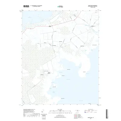
2019 Map of Middletown
USGS Topo · Published 2019About this map
Lake Mattamuskeet and the expansive waters of the Pamlico Sound dominate this coastal Hyde County landscape. The geography is defined by a complex network of drainage features like Gray Ditch, Rose Canal, and Great Ditch Rd, reflecting a long history of water management and agricultural labor in the Lowcountry. Small, dispersed settlements such as Gulrock, Lake Landing, and the curiously named Last Chance are connected by local routes like Gull Rock Rd and Nebraska Rd. The southern shoreline is deeply indented by numerous coves and bays, including Wysocking Bay and Mount Pleasant Bay, while offshore features like Browns Island and Gull Rocks point to the area's maritime character. This map provides a look at the interplay between land and water in one of North Carolina's most distinctive coastal regions.
Find a feature on this map
49 named features on this map. Tap any name to fly to it.
Don’t see what you’re looking for? This feature index may not catch every label — zoom into the map to look around manually.
Map Details
Editions of this 2019 Middletown Map
This is the sole edition of this map. No revisions or reprints were ever made.
Other maps of this area

1943 · Columbia
USGS Topo · 1:125,000

1943 · Roanoke Island
USGS Topo · 1:125,000

1951 · Middletown Anchorage
USGS Topo · 1:24,000
1951 · Bluff Point
USGS Topo · 1:24,000

1951 · Middletown
USGS Topo · 1:24,000

1951 · Engelhard West
USGS Topo · 1:24,000

1951 · New Holland
USGS Topo · 1:24,000

1951 · Engelhard East
USGS Topo · 1:24,000

1951 · Fairfield
USGS Topo · 1:24,000

1953 · Rocky Mount
USGS Topo · 1:250,000