
1951 Map of Middletown
USGS Topo · Published 1952About this map
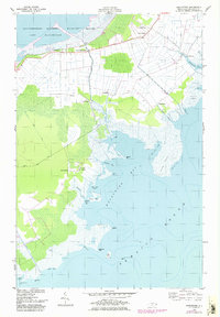
Mattamuskeet Lake and the coastal lowlands of Hyde County define this landscape, where the southern boundary of the Mattamuskeet National Wildlife Refuge meets a network of drainage canals and levees. The early 1950s survey captures a rural environment deeply tied to the water, with several small settlements clustered along the edges of Wysocking Bay and the northern reaches of Pamlico Sound. A string of post offices and small communities, including Lake Landing, Middletown, and the uniquely named Last Chance, are connected by unimproved roads and canals such as the Rose Canal. Local landmarks like Amity Ch and Pleasant Grove Ch suggest established family centers near the shore, while labels for Ruins and scattered lights along the sound hint at the navigation and settlement patterns of this low-lying coastal prairie.
Find a feature on this map
50 named features on this map. Tap any name to fly to it.
Don’t see what you’re looking for? This feature index may not catch every label — zoom into the map to look around manually.
Map Details
Editions of this 1951 Middletown Map
2 editions found
Other maps of this area

1943 · Columbia
USGS Topo · 1:125,000

1943 · Roanoke Island
USGS Topo · 1:125,000

1951 · Middletown Anchorage
USGS Topo · 1:24,000
1951 · Bluff Point
USGS Topo · 1:24,000

1951 · Engelhard West
USGS Topo · 1:24,000

1951 · New Holland
USGS Topo · 1:24,000

1951 · Engelhard East
USGS Topo · 1:24,000

1951 · Fairfield
USGS Topo · 1:24,000

1953 · Rocky Mount
USGS Topo · 1:250,000

1954 · Rocky Mount
USGS Topo · 1:250,000