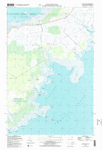
2002 Map of Middletown
USGS Topo · Published 2002About this map
Mattamuskeet National Wildlife Refuge anchors the northern reaches of this coastal landscape, where the waters of Lake Mattamuskeet meet a complex network of man-made drainage features like Gray Ditch and Rose Canal. The settlement pattern follows the higher ground along the margins of the great bays, with established points of interest such as Lake Landing(PO) and Middletown serving as historic local hubs. To the south, the terrain transitions into the protected wetlands of the Gull Rock State Game Land, fronting the expansive Pamlico Sound.
Find a feature on this map
45 named features on this map. Tap any name to fly to it.
Don’t see what you’re looking for? This feature index may not catch every label — zoom into the map to look around manually.
Map Details
Editions of this 2002 Middletown Map
This is the sole edition of this map. No revisions or reprints were ever made.
Other maps of this area

1943 · Columbia
USGS Topo · 1:125,000

1943 · Roanoke Island
USGS Topo · 1:125,000

1951 · Middletown Anchorage
USGS Topo · 1:24,000
1951 · Bluff Point
USGS Topo · 1:24,000

1951 · Middletown
USGS Topo · 1:24,000

1951 · Engelhard West
USGS Topo · 1:24,000

1951 · New Holland
USGS Topo · 1:24,000

1951 · Engelhard East
USGS Topo · 1:24,000

1951 · Fairfield
USGS Topo · 1:24,000

1953 · Rocky Mount
USGS Topo · 1:250,000