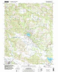
1998 Map of Middletown
USGS Topo · Published 2002About this map
Middletown stands at the junction of several low-lying basins in Lake County, serving as the primary hub where Collayomi Valley meets the lower slopes leading toward the complex drainage of Putah Creek. The landscape here is defined by its series of distinct valleys, including Coyote Valley and Long Valley, which are separated by upland ridges and connected by routes like Butts Canyon Road. The map documents a mix of long-standing rural features, such as the local Cem and a Historical Marker, alongside newer recreational developments centered on Hidden Valley Lake and its associated Golf Course.
Find a feature on this map
42 named features on this map. Tap any name to fly to it.
Don’t see what you’re looking for? This feature index may not catch every label — zoom into the map to look around manually.
Map Details
Editions of this 1998 Middletown Map
This is the sole edition of this map. No revisions or reprints were ever made.
Other maps of this area

1927 · Calistoga
USGS Topo · 1:62,500

1942 · St. Helena
USGS Topo · 1:62,500

1943 · Morgan Valley
USGS Topo · 1:62,500

1943 · Calistoga
USGS Topo · 1:62,500

1944 · Morgan Valley
USGS Topo · 1:62,500

1945 · Calistoga
USGS Topo · 1:62,500

1945 · St. Helena
USGS Topo · 1:62,500

1945 · Lower Lake
USGS Topo · 1:62,500

1947 · Santa Rosa
USGS Topo · 1:250,000

1949 · Santa Rosa
USGS Topo · 1:250,000