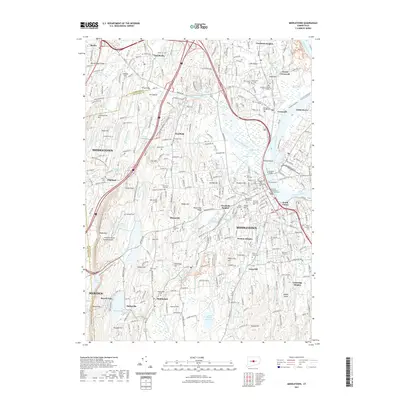
2021 Map of Middletown
USGS Topo · Published 2021About this map
Middletown serves as the central hub of this South Central Connecticut landscape, defined by the winding course of the Connecticut River and the dramatic elevations of the Metacomet Ridge. The area is characterized by a dense concentration of educational and spiritual landmarks, including Wesleyan University and the Holy Apostles College and Seminary. To the west, the terrain rises sharply toward Higby Mtn and Lamentation Mtn, providing a natural boundary that separates the river valley from the neighboring settlement of Meriden. For genealogists and local historians, the map is remarkably detailed in its identification of resting places, from the Old Burying Ground Cem and Saint Sebastian Cem to the State Veterans Cem near South Farms. The transportation network is anchored by the Arrigoni Bridge, which links the bustling street grids to Gildersleeve and Cromwell across the water, while the Mattabesset Trolley Trl follows the path of the Mattabesset River to the north.
Find a feature on this map
114 named features on this map. Tap any name to fly to it.
Don’t see what you’re looking for? This feature index may not catch every label — zoom into the map to look around manually.
Map Details
Editions of this 2021 Middletown Map
This is the sole edition of this map. No revisions or reprints were ever made.
Other maps of this area

1892 · New Haven
USGS Topo · 1:62,500

1892 · Meriden
USGS Topo · 1:62,500

1893 · Guilford
USGS Topo · 1:62,500

1893 · Middletown
USGS Topo · 1:62,500

1893 · Meriden
USGS Topo · 1:62,500

1906 · Farmington
USGS Topo · 1:125,000

1921 · New Haven
USGS Topo · 1:62,500

1928 · Cromwell
USGS Topo · 1:24,000

1928 · Glastonbury
USGS Topo · 1:24,000

1943 · Durham
USGS Topo · 1:25,000