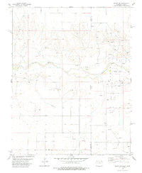
1978 Map of Midway SE
USGS Topo · Published 1978About this map
Cimarron River winds through this arid landscape on the high plains where the borders of Baca County, Colorado, and Morton County, Kansas, meet. The terrain is defined by a dense network of energy infrastructure, with numerous Oil Wells and Gas Wells dotting the drainages and plateaus. These industrial markings are interspersed with landmarks such as Revolution and a Pumping Sta, indicating the intensive natural resource development of the late 1970s. The map also reveals the functional pathways of the era, including a major Pipeline and a Jeep Trail that cut across the section lines. Near the state line, specialized structures like a Radio Tower and a Gravel Pit suggest a landscape focused on utilities and extraction rather than residential settlement, offering a clear record of the region's 20th-century economic footprint.
Find a feature on this map
16 named features on this map. Tap any name to fly to it.
Don’t see what you’re looking for? This feature index may not catch every label — zoom into the map to look around manually.
Map Details
Editions of this 1978 Midway SE Map
This is the sole edition of this map. No revisions or reprints were ever made.
Other maps of this area

1892 · Vilas
USGS Topo · 1:125,000

1954 · Perryton
USGS Topo · 1:250,000

1954 · Dalhart
USGS Topo · 1:250,000

1955 · La Junta
USGS Topo · 1:250,000

1955 · Dodge City
USGS Topo · 1:250,000

1958 · Perryton
USGS Topo · 1:250,000

1958 · La Junta
USGS Topo · 1:250,000

1958 · Dodge City
USGS Topo · 1:250,000

1958 · Dalhart
USGS Topo · 1:250,000

1959 · Dodge City
USGS Topo · 1:250,000