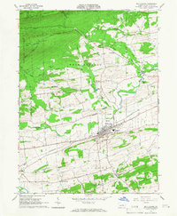
1965 Map of Mifflinburg
USGS Topo · Published 1966About this map
Mifflinburg serves as the central hub of this mid-1960s survey, showing a well-defined town grid intersected by the Pennsylvania railroad line. The landscape transitions from the developed borough to the agricultural fields and forested heights of Seven Notch Mountain and Jones Mountain. Notable landmarks include the Western Area High Sch, a substantial quarry, and various gravel pits that suggest the local extraction industries of the era.
Find a feature on this map
45 named features on this map. Tap any name to fly to it.
Don’t see what you’re looking for? This feature index may not catch every label — zoom into the map to look around manually.
Map Details
Editions of this 1965 Mifflinburg Map
2 editions found
Other maps of this area

1893 · Sunbury
USGS Topo · 1:62,500

1921 · Williamsport
USGS Topo · 1:48,000

1923 · Williamsport
USGS Topo · 1:62,500

1924 · Milton
USGS Topo · 1:62,500

1938 · Mifflinburg
USGS Topo · 1:48,000

1943 · Sunbury
USGS Topo · 1:62,500

1943 · Mifflinburg
USGS Topo · 1:62,500

1944 · Williamsport
USGS Topo · 1:62,500

1950 · Harrisburg
USGS Topo · 1:250,000
1953 · Mifflinburg
USGS Topo · 1:62,500
Featured Places
- Mifflinburg, PA
- Buffalo Township, PA
- Lewis Township, PA
- Red Bank, West Buffalo Township
- West Buffalo Township, PA