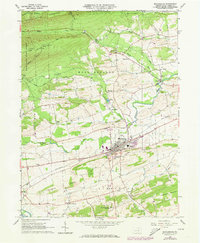
1965 Map of Mifflinburg
USGS Topo · Published 1973About this map
Mifflinburg serves as the central hub of this mid-1960s landscape, where the Penn Central rail line cuts through the heart of the borough. The surrounding countryside of West Buffalo and Lewis townships is a mix of agricultural valley land and high ridges, anchored by Seven Notch Mountain and Limestone Ridge. This survey captures the transition of the local infrastructure during the early 1970s, as evidenced by the presence of Western Area High Sch and the developing Corporate Boundary expansions. Scattered rural settlements like Swengel, Cowan, and White Springs are connected by a network of local routes including Brandon Road and Old Shingle Road. Genealogy researchers will find significant landmarks such as St Peters Ch and Lewis Cem, alongside early industrial traces like the Gravel Pit and Quarry sites that once supported the local economy.
Find a feature on this map
44 named features on this map. Tap any name to fly to it.
Don’t see what you’re looking for? This feature index may not catch every label — zoom into the map to look around manually.
Map Details
Editions of this 1965 Mifflinburg Map
2 editions found
Other maps of this area

1893 · Sunbury
USGS Topo · 1:62,500

1921 · Williamsport
USGS Topo · 1:48,000

1923 · Williamsport
USGS Topo · 1:62,500

1924 · Milton
USGS Topo · 1:62,500

1938 · Mifflinburg
USGS Topo · 1:48,000

1943 · Sunbury
USGS Topo · 1:62,500

1943 · Mifflinburg
USGS Topo · 1:62,500

1944 · Williamsport
USGS Topo · 1:62,500

1950 · Harrisburg
USGS Topo · 1:250,000
1953 · Mifflinburg
USGS Topo · 1:62,500
Featured Places
- Mifflinburg, PA
- Buffalo Township, PA
- Lewis Township, PA
- Red Bank, West Buffalo Township
- West Buffalo Township, PA