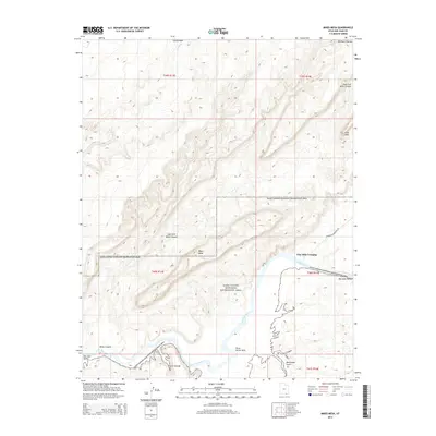
2014 Map of Mikes Mesa
USGS Topo · Published 2014About this map
San Juan River meanders through this portion of the Glen Canyon National Recreation Area, defining the desert landscape south of the Red Rock Plateau. The topography is dominated by dramatic elevation changes, notably at Mikes Mesa and the surrounding Clay Hills. This 2014 survey documents the remote transition from the high plateau down to the San Juan Valley, where drainage systems like Piute Farms Wash and Rockhouse Gulch feed into the river basin. Transport through this arid environment is limited to routes such as Whirlwind Crossing Rd, which provides access toward the river at Clay Hills Crossing. The map provides a high-resolution view of the intricate canyon systems, including the East Fork Mikes Canyon and Castle Wash, illustrating the natural barriers and isolated water sources like Rock Spring that have long dictated movement through San Juan County.
Find a feature on this map
21 named features on this map. Tap any name to fly to it.
Don’t see what you’re looking for? This feature index may not catch every label — zoom into the map to look around manually.
Map Details
Editions of this 2014 Mikes Mesa Map
This is the sole edition of this map. No revisions or reprints were ever made.
Other maps of this area

1886 · Henry Mountains
USGS Topo · 1:250,000

1892 · Henry Mountains
USGS Topo · 1:250,000

1952 · Clay Hills 3 NW
USGS Topo · 1:24,000

1952 · Navajo Mountain 4 NE
USGS Topo · 1:24,000

1952 · Oljeto
USGS Topo · 1:62,500

1953 · Lake Canyon
USGS Topo · 1:62,500

1953 · No Mans Mesa
USGS Topo · 1:62,500

1954 · Clay Hills 2 SW
USGS Topo · 1:24,000

1954 · Clay Hills 2 NW
USGS Topo · 1:24,000
1954 · Clay Hills 3 NE
USGS Topo · 1:24,000