1948 Map of Milan
USGS Topo · Published 1955About this map
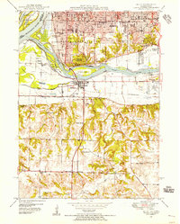
The Rock River dominates this landscape as it winds between Moline and Milan, creating a complex network of landmasses including Vandruff Island and Carr Island. In the late 1940s, the urban expansion of Rock Island is visible through several named additions and neighborhoods such as Fruitland and Bridgeway Addition. High ground south of the river is punctuated by numerous rural schoolhouses and cemeteries that served the agricultural communities of Black Hawk and Bowling townships. Significant landmarks from this era include the County Sanitarium and the Quad City Airport, alongside several private burial grounds like Chippiannock Cem and Hebrew Cem. The transportation infrastructure is defined by the Rock Island Southern and an Abandoned Railroad corridor, reflecting a transition in the local industrial and transit network.
Find a feature on this map
71 named features on this map. Tap any name to fly to it.
Don’t see what you’re looking for? This feature index may not catch every label — zoom into the map to look around manually.
Map Details
Editions of this 1948 Milan Map
This is the sole edition of this map. No revisions or reprints were ever made.
Other maps of this area

1891 · Davenport
USGS Topo · 1:62,500

1892 · Leclaire
USGS Topo · 1:62,500

1893 · Leclaire
USGS Topo · 1:62,500

1894 · Davenport
USGS Topo · 1:62,500

1899 · Clinton
USGS Topo · 1:125,000

1901 · Rock Island
USGS Topo · 1:125,000

1910 · Rock Island
USGS Topo · 1:125,000

1912 · Milan
USGS Topo · 1:62,500

1937 · Orion
USGS Topo · 1:62,500

1944 · Milan
USGS Topo · 1:62,500