1953 Map of Milan
USGS Topo · Published 1959About this map
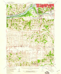
The Mississippi River and Rock River dominate this mid-century landscape, framing the industrial and residential expansion of Moline and South Rock Island. The navigation infrastructure of the era is clearly visible, including Lock No 30 and Lock No 31, which managed river traffic near the busy Davenport Harbor. To the south, the terrain transitions into a dense network of rural school districts and small agricultural settlements like Taylor Ridge and Reynolds.
Find a feature on this map
105 named features on this map. Tap any name to fly to it.
Don’t see what you’re looking for? This feature index may not catch every label — zoom into the map to look around manually.
Map Details
Editions of this 1953 Milan Map
This is the sole edition of this map. No revisions or reprints were ever made.
Other maps of this area

1890 · Durant
USGS Topo · 1:62,500

1891 · Davenport
USGS Topo · 1:62,500

1892 · Leclaire
USGS Topo · 1:62,500

1893 · Leclaire
USGS Topo · 1:62,500

1894 · Durant
USGS Topo · 1:62,500

1894 · Davenport
USGS Topo · 1:62,500

1899 · Clinton
USGS Topo · 1:125,000

1901 · Rock Island
USGS Topo · 1:125,000

1910 · Rock Island
USGS Topo · 1:125,000

1912 · Milan
USGS Topo · 1:62,500