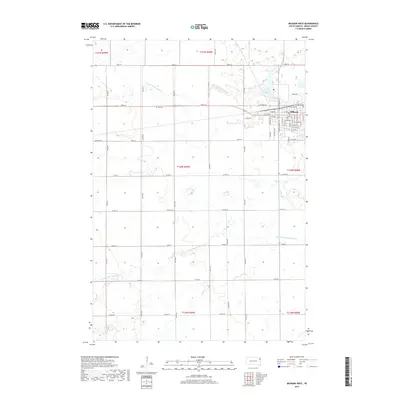
2017 Map of Milbank West
USGS Topo · Published 2017About this map
Milbank anchors the northeastern corner of this Grant County landscape, where the street grid of the town meets the sprawling agricultural sections of northeastern South Dakota. The town's layout is meticulously detailed, showing the concentration of residential and commercial structures along Madison St and South Dakota St, and industrial developments near Industrial Dr. To the west, the rural character of the region is defined by a rigorous section-line road network, including 149th St and Center Rd. Water resources are a prominent feature of this prairie terrain, with the S Fork Whetstone River winding through the northern sections to reach Lake Farley, while the N Fork Yellow Bank River traverses the southern half of the quadrangle. For those researching family history, the Eub Cem is situated along 149th Street, providing a specific landmark for local genealogical study.
Find a feature on this map
60 named features on this map. Tap any name to fly to it.
Don’t see what you’re looking for? This feature index may not catch every label — zoom into the map to look around manually.
Map Details
Editions of this 2017 Milbank West Map
This is the sole edition of this map. No revisions or reprints were ever made.
Other maps of this area

1953 · Milbank
USGS Topo · 1:250,000

1954 · Big Stone Lake
USGS Topo · 1:62,500

1958 · Milbank
USGS Topo · 1:250,000

1971 · Corona
USGS Topo · 1:24,000

1971 · Big Stone Lake SE
USGS Topo · 1:24,000

1971 · Big Stone Lake SW
USGS Topo · 1:24,000

1973 · Twin Brooks
USGS Topo · 1:24,000

1973 · LaBolt
USGS Topo · 1:24,000
1973 · Milbank West
USGS Topo · 1:24,000

1973 · Stockholm
USGS Topo · 1:24,000