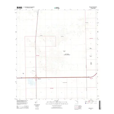
2015 Map of Miles City
USGS Topo · Published 2015About this map
Big Cypress National Preserve dominates this southern Florida landscape, where the intersection of SR 29 and Interstate 75 centers on the small community of Miles City. This environment is characterized by a complex network of cypress heads and hammocks, including named high-ground features such as Hog Island, Platt Island, and Pepper Hammock. These formations represent vital dry-ground refuges within the seasonal wetlands. Significant archaeological and cultural history is evidenced by the East Hinson Indian Mounds near the eastern boundary, while local landmarks like Model T Flat and Layne Hamilton suggest a history of early 20th-century exploration and settlement. Modern transit corridors like Turner River Rd cut through the preservation area, illustrating the balance between wilderness protection and regional connectivity in Collier County.
Find a feature on this map
18 named features on this map. Tap any name to fly to it.
Don’t see what you’re looking for? This feature index may not catch every label — zoom into the map to look around manually.
Map Details
Editions of this 2015 Miles City Map
This is the sole edition of this map. No revisions or reprints were ever made.
Other maps of this area

1956 · West Palm Beach
USGS Topo · 1:250,000

1957 · West Palm Beach
USGS Topo · 1:250,000

1958 · West Palm Beach
USGS Topo · 1:250,000

1958 · Catherine Island
USGS Topo · 1:24,000

1958 · Sunniland
USGS Topo · 1:24,000

1958 · Immokalee SW
USGS Topo · 1:24,000

1959 · Miles City
USGS Topo · 1:24,000

1959 · Deep Lake
USGS Topo · 1:24,000

1959 · Deep Lake SW
USGS Topo · 1:24,000
1962 · Catherine Island
USGS Topo · 1:24,000