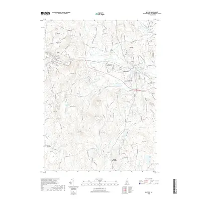
2018 Map of Milford
USGS Topo · Published 2018About this map
The Souhegan River serves as the central artery for this part of Hillsborough County, flowing through the primary settlement at Milford. This region of southern New Hampshire exhibits a dense network of local roads and named topographic features, reflecting centuries of land use and community development. The map details several distinct residential and historical clusters, including Perham Corner in the northwest and the southern edges of Wilton. The landscape is characterized by numerous significant hills such as Federal Hill, Burns Hill, and Abbot Hill, interspersed with small water bodies and wetlands like Osgood Pond and the Rhododendron Swamp. Local historians and genealogists will find several burial grounds documented across the area, from Mount Calvary Cem and Laurel Hill Cem near the river to the more secluded Pratt Cem further south. The southern reaches near North Brookline show a shift toward smaller brooks and ponds, including Melendy Pond and Worcester Millpond.
Find a feature on this map
180 named features on this map. Tap any name to fly to it.
Don’t see what you’re looking for? This feature index may not catch every label — zoom into the map to look around manually.
Map Details
Editions of this 2018 Milford Map
This is the sole edition of this map. No revisions or reprints were ever made.
Other maps of this area

1887 · Fitchburg
USGS Topo · 1:62,500

1889 · Fitchburg
USGS Topo · 1:62,500

1893 · Fitchburg
USGS Topo · 1:62,500

1893 · Groton
USGS Topo · 1:62,500

1900 · Peterboro
USGS Topo · 1:62,500

1906 · Milford
USGS Topo · 1:62,500

1931 · Groton
USGS Topo · 1:48,000

1931 · Fitchburg
USGS Topo · 1:48,000

1935 · Groton
USGS Topo · 1:62,500

1935 · Fitchburg
USGS Topo · 1:62,500