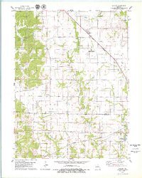
1979 Map of Millard
USGS Topo · Published 1979About this map
The Little Chariton River meanders through the central landscape of this northern Missouri region, defining the drainage patterns of both Pettis and Wilson townships. In the late 1970s, the area maintained a rural character dominated by agricultural field lines, yet it was bisected by significant transportation corridors. The Norfolk and Western and the Atchison Topeka and Santa Fe railroads provide a glimpse into the rail-heavy economy connecting Millard and La Plata. Genealogists will find notable value in the distribution of family-named burial sites like Stukey Cem and Shaver Cem, while the Sugar Creek State Forest preserves a substantial tract of wooded terrain in the west. The presence of the Clarence Cannon Memorial Airport indicates the era's infrastructure development amidst traditional landmarks like the Illinois Bend Ch.
Find a feature on this map
25 named features on this map. Tap any name to fly to it.
Don’t see what you’re looking for? This feature index may not catch every label — zoom into the map to look around manually.
Map Details
Editions of this 1979 Millard Map
This is the sole edition of this map. No revisions or reprints were ever made.
Other maps of this area

1903 · Edina
USGS Topo · 1:125,000

1908 · Atlanta
USGS Topo · 1:62,500

1937 · Elmer
USGS Topo · 1:48,000

1938 · Kirksville
USGS Topo · 1:62,500

1940 · Kirksville
USGS Topo · 1:62,500

1942 · Elmer
USGS Topo · 1:62,500

1953 · Moberly
USGS Topo · 1:250,000

1954 · Centerville
USGS Topo · 1:250,000

1954 · Moberly
USGS Topo · 1:250,000

1957 · Moberly
USGS Topo · 1:250,000