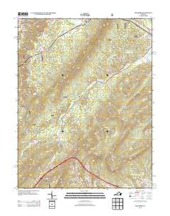
2013 Map of Millboro
USGS Topo · Published 2013About this map
Rockbridge Alum Springs and the village of Millboro anchor this 2013 topographic study of the western Virginia highlands. The landscape is defined by its spring-fed history and complex rail engineering, featuring both the Millboro Tunnel and Lick Run Tunnel carved through the mountain ridges. Settlement patterns follow the narrow drainage basins of Brattons Run and Alum Cr, where small communities like California and Sycamore Valley are situated.
Find a feature on this map
49 named features on this map. Tap any name to fly to it.
Don’t see what you’re looking for? This feature index may not catch every label — zoom into the map to look around manually.
Map Details
Editions of this 2013 Millboro Map
This is the sole edition of this map. No revisions or reprints were ever made.
Other maps of this area

1894 · Staunton
USGS Topo · 1:125,000

1894 · Natural Bridge
USGS Topo · 1:125,000

1894 · Lexington
USGS Topo · 1:125,000

1901 · Monterey
USGS Topo · 1:125,000

1932 · Lexington
USGS Topo · 1:48,000

1937 · Lexington
USGS Topo · 1:62,500

1943 · Craigsville
USGS Topo · 1:62,500

1945 · Craigsville
USGS Topo · 1:62,500

1946 · Millboro
USGS Topo · 1:62,500

1946 · Williamsville
USGS Topo · 1:62,500