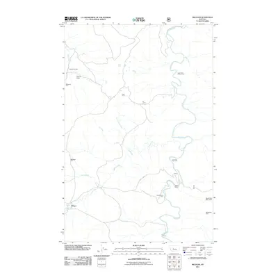
2011 Map of Millegan
USGS Topo · Published 2011About this map
The Smith River snakes through this high-altitude landscape, carving a deep canyon that dominates the geography between the Big Belt and Little Belt ranges. Small settlements and individual homesteads like Millegan and Carlson are scattered across the terrain, connected by rural routes such as Smith River Ln. The area serves as a significant recreational corridor, evidenced by the Upper Parker Flat Boat Camp and Trout Creek Boat Camp along the river's winding path.
Find a feature on this map
24 named features on this map. Tap any name to fly to it.
Don’t see what you’re looking for? This feature index may not catch every label — zoom into the map to look around manually.
Map Details
Editions of this 2011 Millegan Map
This is the sole edition of this map. No revisions or reprints were ever made.
Other maps of this area

1886 · Great Falls
USGS Topo · 1:250,000

1886 · Fort Logan
USGS Topo · 1:250,000

1948 · White Sulphur Springs
USGS Topo · 1:250,000

1954 · Great Falls
USGS Topo · 1:250,000

1957 · Great Falls
USGS Topo · 1:250,000

1958 · White Sulphur Springs
USGS Topo · 1:250,000

1961 · White Sulphur Springs
USGS Topo · 1:250,000

1965 · White Sulphur Springs
USGS Topo · 1:250,000

1966 · Lingshire NE
USGS Topo · 1:24,000
1966 · Lingshire NW
USGS Topo · 1:24,000