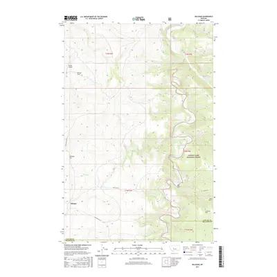
2017 Map of Millegan
USGS Topo · Published 2017About this map
Millegan stands as a focal point in this high-plains landscape where the Cascade Co and Meagher Co boundary meets the western edge of the Lewis & Clark National Forest. The settlement is situated near Millegan Hill, serving as a waypoint for travelers on Upper Millegan Rd. The terrain is deeply incised by a network of drainage systems, most notably the Smith River which carves a winding path through the eastern portion of the quadrangle.
Find a feature on this map
23 named features on this map. Tap any name to fly to it.
Don’t see what you’re looking for? This feature index may not catch every label — zoom into the map to look around manually.
Map Details
Editions of this 2017 Millegan Map
This is the sole edition of this map. No revisions or reprints were ever made.
Other maps of this area

1886 · Great Falls
USGS Topo · 1:250,000

1886 · Fort Logan
USGS Topo · 1:250,000

1948 · White Sulphur Springs
USGS Topo · 1:250,000

1954 · Great Falls
USGS Topo · 1:250,000

1957 · Great Falls
USGS Topo · 1:250,000

1958 · White Sulphur Springs
USGS Topo · 1:250,000

1961 · White Sulphur Springs
USGS Topo · 1:250,000

1965 · White Sulphur Springs
USGS Topo · 1:250,000

1966 · Lingshire NE
USGS Topo · 1:24,000
1966 · Lingshire NW
USGS Topo · 1:24,000