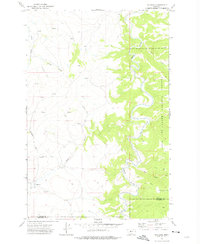
1971 Map of Millegan
USGS Topo · Published 1975About this map
Millegan stands as the primary landmark in this ranching and river landscape of central Montana, situated near the western edge of the Lewis and Clark National Forest. The geography is defined by the deeply incised winding channel of the Smith River, which snakes through the eastern half of the quadrangle. The river’s course is marked by numerous fords and a network of unimproved roads and a Jeep Trail, indicating a working landscape where access to the water was essential for movement through the broken terrain.
Find a feature on this map
21 named features on this map. Tap any name to fly to it.
Don’t see what you’re looking for? This feature index may not catch every label — zoom into the map to look around manually.
Map Details
Editions of this 1971 Millegan Map
This is the sole edition of this map. No revisions or reprints were ever made.
Other maps of this area

1886 · Great Falls
USGS Topo · 1:250,000

1886 · Fort Logan
USGS Topo · 1:250,000

1948 · White Sulphur Springs
USGS Topo · 1:250,000

1954 · Great Falls
USGS Topo · 1:250,000

1957 · Great Falls
USGS Topo · 1:250,000

1958 · White Sulphur Springs
USGS Topo · 1:250,000

1961 · White Sulphur Springs
USGS Topo · 1:250,000

1965 · White Sulphur Springs
USGS Topo · 1:250,000

1966 · Lingshire NE
USGS Topo · 1:24,000
1966 · Lingshire NW
USGS Topo · 1:24,000