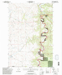
1995 Map of Millegan
USGS Topo · Published 1997About this map
The Smith River winds through a dramatic canyon landscape along the eastern boundary of this mid-1990s survey, marking a sharp transition between the Lewis and Clark National Forest and the ranch lands to the west. The area is defined by complex drainage systems like Trout Creek and Clark Creek that carve through the high country. Isolated points of habitation such as Millegan and the Dick Anderson Cabin reflect the rural character of this region on the border of Cascade and Meagher counties. The map illustrates the geography of the Kings Hill Ranger District, featuring distinctive river landmarks like Paradise Bend and Table Rock. A network of unpaved tracks and 4wd routes provides the primary access through the steep terrain, connecting high points like Millegan Hill with the river corridor.
Find a feature on this map
31 named features on this map. Tap any name to fly to it.
Don’t see what you’re looking for? This feature index may not catch every label — zoom into the map to look around manually.
Map Details
Editions of this 1995 Millegan Map
This is the sole edition of this map. No revisions or reprints were ever made.
Other maps of this area

1886 · Great Falls
USGS Topo · 1:250,000

1886 · Fort Logan
USGS Topo · 1:250,000

1948 · White Sulphur Springs
USGS Topo · 1:250,000

1954 · Great Falls
USGS Topo · 1:250,000

1957 · Great Falls
USGS Topo · 1:250,000

1958 · White Sulphur Springs
USGS Topo · 1:250,000

1961 · White Sulphur Springs
USGS Topo · 1:250,000

1965 · White Sulphur Springs
USGS Topo · 1:250,000

1966 · Lingshire NE
USGS Topo · 1:24,000
1966 · Lingshire NW
USGS Topo · 1:24,000