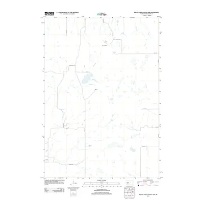
2012 Map of Miller Dale Colony NW
USGS Topo · Published 2012About this map
Ree Hills rise above the agricultural plains of Hand County in this 2012 survey, providing a distinct topographic break in the prairie landscape. The small settlement of Ree Heights sits at the northern edge of the hills, marking a localized hub for the surrounding ranchlands. The area's drainage is defined by the wandering paths of Elm Cr in the southwest and Little Turtle Cr to the north, which cut through a network of section-line roads and family-named thoroughfares. Local genealogy and land use are reflected in the naming of rural routes like Sivertsen Pl, Cook Pl, and Hasart Rd. The map illustrates a contemporary rural infrastructure where large-scale farming and grazing are supported by a grid of numbered avenues and streets, such as 348th Ave and 202nd St, which overlay the natural undulations of the hills.
Find a feature on this map
20 named features on this map. Tap any name to fly to it.
Don’t see what you’re looking for? This feature index may not catch every label — zoom into the map to look around manually.
Map Details
Editions of this 2012 Miller Dale Colony NW Map
This is the sole edition of this map. No revisions or reprints were ever made.
Other maps of this area

1950 · Ree Heights SE
USGS Topo · 1:24,000

1950 · Ree Heights
USGS Topo · 1:24,000

1950 · Highmore SE
USGS Topo · 1:24,000

1953 · Huron
USGS Topo · 1:250,000

1954 · Huron
USGS Topo · 1:250,000

1973 · Ames
USGS Topo · 1:24,000

1973 · Macs Corner NE
USGS Topo · 1:24,000

1973 · Miller Dale Colony SW
USGS Topo · 1:24,000

1973 · Macs Corner SE
USGS Topo · 1:24,000
1973 · Miller Dale Colony NW
USGS Topo · 1:24,000