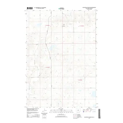
2015 Map of Miller Dale Colony NW
USGS Topo · Published 2015About this map
Ree Heights sits at the northern edge of the Ree Hills in Hand County, marking a distinct transition in the South Dakota prairie. This area is defined by a grid of rural avenues and section roads, including 348th Ave and 349th Ave, which serve a landscape of isolated farmsteads and agricultural plots. The drainage of Little Turtle Cr provides the primary hydrological feature in the northeast, while the rest of the terrain is characterized by the undulating elevations of the hills. Local naming conventions are preserved through thoroughfare labels like Sivertsen Pl, Hasart Rd, and Cook Pl, reflecting the enduring legacy of family landholdings in this part of the state. The layout of Green Valley Rd and various numbered section lines, such as 201st St and 206th St, illustrates the persistent township and range system that has organized this rural territory for generations.
Find a feature on this map
22 named features on this map. Tap any name to fly to it.
Don’t see what you’re looking for? This feature index may not catch every label — zoom into the map to look around manually.
Map Details
Editions of this 2015 Miller Dale Colony NW Map
This is the sole edition of this map. No revisions or reprints were ever made.
Other maps of this area

1950 · Ree Heights SE
USGS Topo · 1:24,000

1950 · Ree Heights
USGS Topo · 1:24,000

1950 · Highmore SE
USGS Topo · 1:24,000

1953 · Huron
USGS Topo · 1:250,000

1954 · Huron
USGS Topo · 1:250,000

1973 · Ames
USGS Topo · 1:24,000

1973 · Macs Corner NE
USGS Topo · 1:24,000

1973 · Miller Dale Colony SW
USGS Topo · 1:24,000

1973 · Macs Corner SE
USGS Topo · 1:24,000
1973 · Miller Dale Colony NW
USGS Topo · 1:24,000